Asset intelligence for energy and wildfire risk

Independent condition data for the assets you own, insure and finance.

Tessera captures radiometric thermal and survey-grade imagery of solar plants, battery-storage sites and wildfire-exposed property, then turns it into a located, analyst-reviewed record of asset condition that you can compare year over year.

Methods written down, every finding located and signed by an analyst, and the data is yours: in every delivery.

B04-S12-M07ΔT +32 °F
IEC TS 62446-3Aerial thermography method for photovoltaic plants
600 W/m²Flight window06:0012:0018:00
600 W/m²Minimum plane-of-array irradiance for solar captures, logged per flight
Zone 0 · 0–5 ftember-resistantZone 1 · 30 ftlean, clean, greenZone 2 · 100 ftreduced fuel
0–5 · 30 · 100 ftDefensible-space zones mapped from every wall, per PRC 4291 and the 2026 Zone 0 rules
CaptureScreenAnalystReportfalse positive removedevery flagsigned
100% reviewedEvery reported finding reviewed by an analyst before delivery
  • FAA Part 107 certified pilots
  • Level 1 certified thermographer
  • Insured, certificate with every proposal
  • Independent: no repair or contractor ties
The record

Every finding located, rated and signed.

Each delivery includes a findings register your team can work from directly: asset ID, finding, severity and repair status, with a thermal and visual image pair behind every line.

View sample reports

Who we serve

One record. Read by everyone with a stake in the asset.

Operators use it to fix things. Owners, lenders and insurers use the same record to understand condition and risk. We build each deliverable for the person who has to act on it.

Asset owners and IPPs

Annual condition baselines across solar and storage portfolios.

  • Site-by-site comparability
  • Revenue-at-risk estimates
  • Warranty and claim support

O&M providers

Located, prioritized work lists that drop into your CMMS.

  • Findings by block, string, module
  • Asset-ID matched registers
  • Repair verification flights

Lenders, investors and engineers

Independent field data for acquisitions, refinancings and portfolio reviews.

  • Pre-close condition scans
  • Data packages for your independent engineer
  • No ties to repair vendors

Insurers and brokers

Documented mitigation for wildfire-exposed homes and communities.

  • Zone 0 to Zone 2 condition by parcel
  • Dated before-and-after records
  • Community-level summaries

HOAs and communities

A readiness report for every home and a plan for the board.

  • Owner-level fix lists
  • Common-area findings
  • Firewise USA support
Programs

Recurring programs. Scoped and priced per site.

Condition data is most valuable when it's collected the same way every year. Each program has a fixed scope, a fixed price and a defined data package.

All services

Solar
Solar owners and O&M

Solar Site Annual Program

A full-plant radiometric thermal survey to IEC TS 62446-3, flown in the spring and summer irradiance window.

  • Anomaly register by block, string and module
  • Severity classes, repair priorities and revenue at risk
Storage
Battery-storage owners and operators

Battery-Storage Site Program

A pre-summer exterior thermal and visual survey of enclosures, inverters and transformers, flown during a discharge window.

  • Cooling faults, hot terminals and seal leaks flagged
  • Findings matched to your asset IDs
Transactions
Lenders, investors and independent engineers

Transaction Condition Survey

An independent pre-close thermal and visual survey of a plant or portfolio, delivered in a format your independent engineer and counsel can use.

  • Full-plant anomaly register with severity
  • Estimated energy and revenue at risk
Communities
HOAs, Firewise USA sites and home sellers

Defensible-Space Program

From $95 per home

A spring mapping flight over the community, a readiness report for every home and a board summary, with a recheck flight before fire agency inspections. Single-home pre-listing reports are available year-round.

  • Zone 0, 1 and 2 checklist for each parcel
  • Numbered fix list with photos, timing and cost guide
The platform

Software screens. Analysts sign.

Tessera's own processing pipeline turns each flight into a consistent, located record. Automation means every module, enclosure and parcel gets looked at. A trained analyst reviews every flag before it reaches a report.

How it works
01 · CAPTURE

Fly to specification

Radiometric thermal and RGB imagery with RTK positioning, inside the irradiance, wind and airspace limits for the job.

02 · DETECT

Screen everything

Automated detection flags thermal anomalies and defensible-space conditions across the full site, not a sample.

03 · REVIEW

Analyst sign-off

Each flag is confirmed or rejected, measured, classed by severity and given a recommended action.

04 · RECORD

Deliver and compare

A signed report and data package, structured to line up with prior seasons and across sites.

Sample reports

Review the deliverable before you engage.

Four complete sample reports in the format we deliver, from a 20 MW solar plant to a single homeowner's parcel report.

See all four

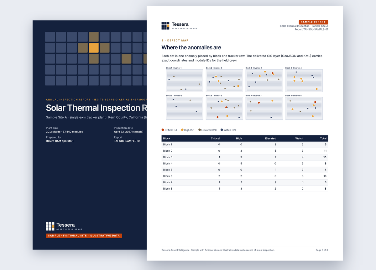
Solar thermal inspectionA 20 MW single-axis plant: 64 anomalies mapped to block, string and module, with severity, revenue at risk and a repair priority list.
Cover and defect map page of the sample solar thermal inspection report
Open PDF · 7 pages
HOA community readinessReadiness by home, common-area items and the season plan for the board.
Cover and neighborhood map page of the sample HOA community readiness report
Open PDF · 6 pages
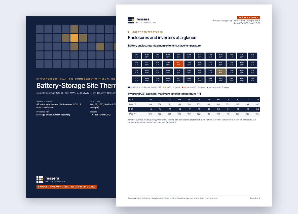
Battery-storage site scanEnclosure and inverter temperatures surveyed during discharge, with logbook-ready entries.
Cover and asset temperature page of the sample battery-storage site scan
Open PDF · 5 pages
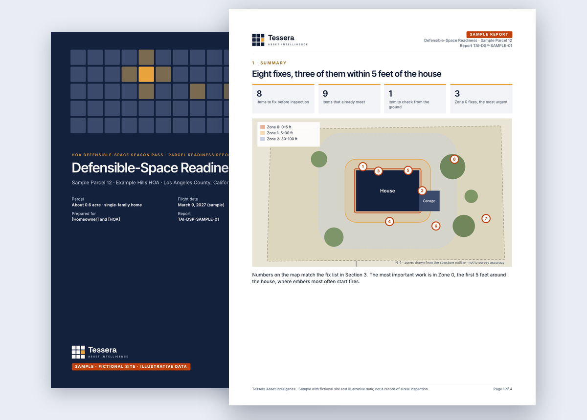
Homeowner parcel reportThe report each owner receives: zone map, checklist and numbered fixes with timing and cost guidance.
Cover and parcel map page of the sample defensible-space readiness report
Open PDF · 5 pages

Samples use fictional sites and illustrative data. They are not records of real inspections.

Service areas

Local operators. San Luis Obispo to San Diego.

Our operators are based across each region below, so flights, rechecks and urgent re-flights are scheduled locally, by people who know who inspects, when inspections start and where the airspace gets tight.

Map of Tessera service areas from San Luis Obispo County to San Diego County: 1. Palos Verdes Peninsula; 2. South Bay beach cities; 3. Malibu and the Santa Monica Mountains; 4. Ventura County; 5. Orange County; 6. San Diego County; 7. Carrizo Plain and San Luis Obispo County; 8. Kern County and the Antelope Valley; 9. Inland Empire and the desert SAN BERNARDINO SANTA BARBARA IMPERIAL VENTURA ORANGE KERN RIVERSIDE SAN LUIS OBISPO SAN DIEGO LOS ANGELES Pacific Ocean MEXICO 1 2 3 4 5 6 7 8 9 50 mi
9service areas
8counties

Primary work in each area

  • Wildfire readiness4
  • Solar and battery storage3
  • Wildfire, solar and storage2
  1. 1Palos Verdes Peninsula
  2. 2South Bay beach cities
  3. 3Malibu and the Santa Monica Mountains
  4. 4Ventura County
  5. 5Orange County
  6. 6San Diego County
  7. 7Carrizo Plain and San Luis Obispo County
  8. 8Kern County and the Antelope Valley
  9. 9Inland Empire and the desert
Guide

California's Zone 0 rules, explained for homeowners and HOAs

What the 2026 ember-resistant zone rules require within five feet of a home, what applies now and what phases in.

Read the guide →

Records that hold up. Season after season.

Tell us about the site, community or portfolio. We reply within one business day with questions or a fixed-scope proposal.

Request a proposal